Midlothian's eight areas, from the village to Evergreen: ZIP codes 23114 and 23113, the Midlothian High zone and Zillow home values by ZIP code.
Last checked Oct. 19, 2026. Sources: the Census Bureau’s boundary for the Midlothian census-designated place, Chesterfield County’s open GIS data (subdivision records, address points, school attendance zones, ZIP code and park layers), the county’s Midlothian Community Special Area Plan, the Virginia Department of Education’s School Quality Profiles, Zillow Research and OpenStreetMap.
Midlothian has no town limits. It is an unincorporated census-designated place in Chesterfield County, about 8.6 square miles of land inside a boundary the Census Bureau draws, with 19,120 residents in the bureau’s 2020-2024 American Community Survey. Chesterfield County runs the government, police, fire and parks, and Chesterfield County Public Schools runs the schools. So “which part of Midlothian” is a question about subdivisions, school zones and ZIP codes. This guide splits Midlothian into eight areas and gives each its own page.
What this means for you
- One high school: all but one of the 10,059 county address points inside the Census boundary are zoned for Midlothian High. The elementary and middle school splits are what change from area to area.
- Two ZIP codes: 23114 covers most of Midlothian; 23113 covers the north side of Midlothian Turnpike. A “Midlothian” mailing address can also mean 23112, which covers Brandermill and Woodlake outside the Census boundary.
- Check the address, not the ZIP: school zones do not follow ZIP codes or the Census line. Use the division’s Find My School lookup.
How Midlothian is laid out
Midlothian Turnpike, U.S. 60, crosses the north end east and west. Route 288 forms most of the western edge and cuts across the southwest, and Powhite Parkway (Route 76) runs along the south. Charter Colony Parkway, Coalfield Road and North Woolridge Road run north and south through the middle, and Lucks Lane crosses the south. Falling Creek is close to the eastern edge.
The historic village sits on Midlothian Turnpike. The county’s Midlothian Community Special Area Plan, adopted in 2019, calls it the village core and says all three public schools in the plan area, the library and Fire Station 5 are inside it. South of the turnpike the land is mostly subdivisions recorded from the 1970s to the 2020s, from Walton Park and Queensmill to Charter Colony and the Centerpointe apartments by Route 288.
About 72% of Midlothian’s land is in the county’s Midlothian magisterial district and 28% in the Clover Hill district, which matters for who represents you on the Board of Supervisors and the School Board.
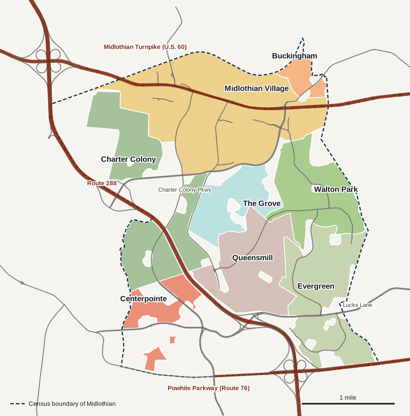
Map: Midlothian Now, from the Census Bureau’s Midlothian boundary and Chesterfield County subdivision, design district and street centerline data. Shaded areas are recorded subdivisions and the village district; unshaded land inside the line is mostly undivided land, campuses and parks.
The eight areas at a glance
Home values are the Zillow Home Value Index for September 2026, a modeled typical value for the middle third of homes in the whole ZIP code, not a sale price. Zillow’s figure for its Midlothian area, which takes in all three Midlothian ZIP codes, was $468,594.
| Area | ZIP code | Zoned high school | Typical home value in its ZIP | Guide |
|---|---|---|---|---|
| Midlothian Village | 23114 south of the turnpike, 23113 north | Midlothian High | $468,325 (23114), $720,126 (23113) | Midlothian Village |
| Charter Colony | 23114 | Midlothian High | $468,325 | Charter Colony |
| Centerpointe | 23114 | Midlothian High | $468,325 | Centerpointe |
| The Grove | 23114 | Midlothian High | $468,325 | The Grove |
| Queensmill | 23114 | Midlothian High | $468,325 | Queensmill |
| Walton Park | 23114 | Midlothian High | $468,325 | Walton Park |
| Evergreen | 23114 | Midlothian High | $468,325 | Evergreen |
| Buckingham | 23113 | Midlothian High | $720,126 | Buckingham |
Midlothian Village
The village core along Midlothian Turnpike, with Sycamore Square, the Midlothian Library, J.B. Watkins Elementary, Midlothian Middle and Midlothian High, plus the apartments, condominiums and townhouses around them. It has the most addresses of any area. Read the Midlothian Village guide.
Charter Colony
The planned community of “villages” on both sides of Charter Colony Parkway in the west, recorded mostly from 2003 to 2012, next to Brightpoint Community College’s Midlothian campus. Its elementary zone splits between Watkins and Evergreen. Read the Charter Colony guide.
Centerpointe
The newest area, by Route 288 and Powhite Parkway, mostly apartments and townhouses recorded since 2013, next to Bon Secours St. Francis Medical Center and Tomahawk Creek Middle. Read the Centerpointe guide.
The Grove
Eight sections recorded from 1998 to 2005 next to Mid-Lothian Mines Park and its Grove Shaft ruins. Read The Grove guide.
Queensmill
Queensmill and its newer neighbors Queensgate and Queensbluff, between The Grove and Lucks Lane, zoned for Evergreen Elementary and Tomahawk Creek Middle. Read the Queensmill guide.
Walton Park
Walton Park and Stonehenge West on the east side along Walton Park Road and Queensgate Road, recorded from 1976 to 1999. Read the Walton Park guide.
Evergreen
The southeast corner along Evergreen East Parkway and Lucks Lane, including Walton Lake, Abbots Mill and Sachems Head, around Evergreen Elementary. Read the Evergreen guide.
Buckingham
The smallest area, north of Midlothian Turnpike at the eastern edge, in ZIP code 23113 and the Robious Elementary zone. Read the Buckingham guide.
Next door
Brandermill, Bon Air and Manchester are separate census-designated places, also governed by Chesterfield County, and Brandermill and Woodlake share Midlothian mailing addresses. For taxes, schools, incomes and commutes side by side, see Midlothian vs. Brandermill vs. Bon Air vs. Manchester.
More for new residents
- Midlothian home prices
- Midlothian schools guide
- Chesterfield County property taxes
- Parks and trails in Midlothian
- Getting around Midlothian
- Moving to Midlothian
- A guide to Midlothian Village
How we built this
Midlothian has no official neighborhood map, so we built the areas from records we can cite:
- The Census Bureau’s Midlothian boundary sets the outer edge. Land outside it, such as Brandermill, Woodlake and Salisbury, is not on these pages even when it has a Midlothian mailing address.
- Chesterfield County’s subdivision records in its open GIS data name every recorded subdivision and section, with the date each was recorded. The county groups many sections under one name, such as Charter Colony, The Grove and Evergreen; we kept those groups.
- The county’s Midlothian Community Special Area Plan defines the village core. We drew the village from the county’s Midlothian Special Design District layer, which covers it.
- County address points carry each address’s ZIP code and its elementary, middle and high school, so school shares on each page are shares of an area’s addresses, counted Oct. 19, 2026.
- OpenStreetMap supplied place names such as Charter Colony, The Grove, Queensmill, Walton Park and Walton Lake, plus stores and community buildings.
Area names come from the county’s subdivision records and OpenStreetMap. Nothing on these pages rates or ranks the areas. Always check a specific address with the county and the school division.
Frequently asked questions
What are the neighborhoods in Midlothian, Virginia?
Our guide splits Midlothian into eight areas: Midlothian Village, Charter Colony, Centerpointe, The Grove, Queensmill, Walton Park, Evergreen and Buckingham, each built from Chesterfield County subdivision records and planning maps.
What ZIP code is Midlothian, Virginia?
Most of the Census Bureau’s Midlothian, about 86% of its land, is in ZIP code 23114. The north side of Midlothian Turnpike is mostly 23113. ZIP code 23112, also a Midlothian mailing address, covers Brandermill and Woodlake to the south.
What high school serves Midlothian?
Midlothian High School, 401 Charter Colony Parkway. All but one of the 10,059 county address points inside the Census boundary are zoned for it in the county’s data, checked Oct. 19, 2026.
Is Midlothian a town?
No. Midlothian is an unincorporated census-designated place in Chesterfield County, about 8.6 square miles. The county runs its government, police, fire, parks and roads planning, and Chesterfield County Public Schools runs the schools.
Have your say